THERMAL

Welcome to Tesla's Drones, where we specialize in providing high-quality drone thermal imaging solutions that help you achieve your goals!
We understand that you're looking for a powerful tool that can detect temperature variations in real-world objects and environments, and we're excited to be able to offer you just that.
At Tesla's Drones, we take pride in building relationships with our clients, and we strive to ensure that you have the best experience possible with us. Our team of experts is dedicated to understanding your unique needs and providing you with customized solutions that meet those needs perfectly.
Whether you're in agriculture, building inspection, or search and rescue operations, we are committed to helping you identify areas of concern or interest, and providing you with the tools you need to take proactive measures. So, let us help you achieve success in your field - choose Tesla's Drones for all your thermal imaging needs.
TURNING UP THE HEAT ON YOUR BUSINESS OPERATIONS
ABOUT
WHAT WE OFFER
We use our drones to gather valuable data with multiple maps and data sets


THERMAL IMAGING
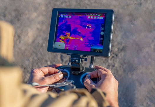
Thermal images can present you with sophisticated data that can be used for diagnosing problems outright, or the images can be processed through specialized software for further evaluation, accuracy, and report output. Our thermal imaging cameras save the measurements of temperatures in every pixel using radiometry making it exceptionally accurate data, that is also easily analyzed from the comfort of your desk.
Thermal imaging can be used for many different sectors from construction, solar installation, search and rescue, roof inspections, mining, electrical inspections, agricultural inspections, archeology, surveillance, wildlife surveying, animal rescue, gas leak detections, and many more yet undiscovered uses for thermal drones!
Reduce the amount of time you spend on manual thermal inspections previously done by foot. Thermal imaging drones can scan continuously meaning jobs that normally take days, now take only a few hours to complete.
THERMAL ORTHOMOSAIC MAPS
An orthomosaic drone map created using thermal imaging technology provides clients with a wealth of benefits that can positively impact their business operations.
With this advanced mapping solution, clients can gain a better understanding of their property by detecting temperature variations, which can indicate potential issues such as leaks, energy inefficiencies, or crop stress. This is also amazing technology for detecting environmental issues over time.
By identifying these issues early, clients can take proactive measures to address them, reducing costs and improving their bottom line.
THERMAL 3D MODEL
I am excited to introduce you to a cutting-edge service that takes drone thermal imaging to the next level! Our service allows us to transform thermal imaging data into a thermal 3D model, providing you with an even more detailed view of temperature patterns from an aerial perspective.
Thermal 3D models offer a comprehensive and accurate view of temperature data by creating a three-dimensional model of the area being observed. With this technology, you can examine temperature patterns from any angle, providing you with a more comprehensive view of the data.
This allows us to identify potential issues with even greater precision, providing you with more accurate and reliable results. The possibilities are truly endless, and we are excited to be at the forefront of this innovative field
AGRICULTURAL INSPECTIONS
Cutting-edge drone technology now makes crop monitoring, measuring and managing faster, easier, and safer than ever before.
Quickly identify large problems with water stress, weed infestations, early detection of pest infestation, and plant disease analysis. In addition to detecting problems, our software algorithms can also count plants and calculate overall yield with an exceptionally high rate of accuracy.
We can cover around 500 acres in less than 2 hours. Every map is carefully examined by an agricultural expert from Agremo in order to produce an error rate of only 2% so you can rely on our data to be reliable and accurate.
You can use this valuable information to create preventative countermeasures to save your crops, plan for next years seeding, or to measure crop outputs and where they may be lacking.
In an industry that is rapidly moving towards automation, utilizing drones to gather and analyze agriculture data is an essential step towards maintaining a competitive edge.
ROOF REPORTS
Why use thermal imaging for your solar panels? The most straight forward answer is: it's incredibly efficient! You can find heat anomalies in a fraction of the time it would take a team of technicians on the ground.
This is especially true if we create thermal imaging orthomosaics where we can pinpoint possible faults in order to show your technicians right where to look.
When we take these images, we are looking for heat differences that can indicate a problem. This can include cell-level defects or entire string defects. We can not only help you keep track of defects, but we can make sure that when your solar panels are first installed, everything is operating the way that it should.
Technically our drones do not diagnose problems - What our drones do is give your technicians all the valuable information they need to detect problems, while significantly reducing inspection and diagnostic times!
EXAMPLES
THERMAL INSPECTIONS
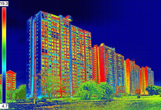
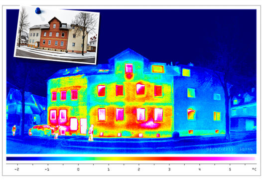
Drone thermal imaging is a revolutionary technology that utilizes specialized cameras to capture and record temperature data from an aerial perspective. With this technology, you can identify heat loss, water leakage, and insulation issues in your home or commercial building. Information like this can provide you and your team with actionable insights to make informed decisions about energy efficiency and repairs.
Drone thermal imaging is an incredibly efficient and cost-effective way to inspect large areas and identify potential issues quickly. It is especially useful for the construction and roofing industries, as well as for home and building inspections.


THERMAL ORTHOMOSAIC & 3D MODEL
Drone thermal imaging is a revolutionary technology that captures and records temperature data from an aerial perspective. But did you know that we can take this technology even further by turning the thermal images into a thermal orthomosaic and a thermal 3D model?
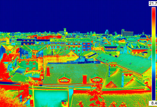
Thermal orthomosaics are created by stitching together multiple thermal images to create a detailed aerial view of the temperature patterns in an area over a period of time. This information can be incredibly useful for identifying areas of energy loss in buildings, detecting hotspots in electrical systems, or even locating wildlife at night.
Thermal 3D models, on the other hand, take the thermal imaging data to the next level by creating a three-dimensional model of the area. This provides an even more detailed view of the temperature patterns and can help you identify issues more precisely. With a thermal 3D model, you can examine the temperature patterns from any angle, providing a more comprehensive view of the data.
THERMAL PLANT HEALTH ANALYSIS
Thermal imaging is a powerful tool that can be used to gather critical information for farmers when conducting a plant health analysis. By using thermal imaging technology, we can accurately detect temperature variations in crops and identify areas of stress or disease that may be limiting yield.
With our plant health analysis service, you'll receive a comprehensive assessment of your crop's health, including the exact percentage, size, and location of stress zones in your crops. This information is then compiled into a detailed report that includes a map of your field, highlighting both healthy and problem-causing areas.
By ordering our plant health analysis service, you can take timely action to improve your crop yield and increase your revenue. Our service is proven to be effective with forestry, field, and plantation crops, as well as vegetables. So why wait? Invest in our plant health analysis service today and get the insights you need to optimize your crop management.
THERMAL ROOF REPORT
Drone thermal imaging is a revolutionary technology that utilizes specialized cameras to capture and record temperature data from an aerial perspective. With this technology, you can identify heat loss, water leakage, and insulation issues in your home or commercial building. Information like this can provide you and your team with actionable insights to make informed decisions about energy efficiency and repairs.
Drone thermal imaging is an incredibly efficient and cost-effective way to inspect large areas and identify potential issues quickly. It is especially useful for the construction and roofing industries, as well as for home and building inspections.

Price factors can include weather, the complexity of job location, drive times, number of flights required, time on location, video resolution (6k available), number of files needed, editing time, if there are multiple areas to be filmed, etc. Please contact us to get a more accurate quote.
THERMAL INSPECTION
STARTING AT:
$300 AN HOUR
We will take thermal images with a 640x512 radiometric thermal imaging camera at the location of your choosing. These images can be useful for diagnosing solar panels, looking for insulation leaks in roofs or even entire houses or buildings, following liquid leaks in pipelines, and much much more. You will receive all unedited thermal JPG image files, and an unedited mp4 file of the video as well.
THERMAL ORTHOMOSAIC
STARTING AT:
$300 AN HOUR
We provide you with a fully up-to-date interactive thermal 2D digital model that allows you to take measurements such as height, depth, length, area, and volume with 99.4% accuracy.
THERMAL AGRICULTURAL INSPECTIONS
STARTING AT:
$350 AN HOUR
We take a thernal orthomosaic of your farm. We provide you the agricultural inspection overview through our 2-D mapping software that also provides you with a fully up-to-date interactive 2D digital model that allows you to take measurements such as height, depth, length, area, and volume with 99.4% accuracy. We can map on average 500 acres every two hours.
THERMAL ROOF INSPECTION
STARTING AT:
$350
We will take thermal images of your roof with a 640x512 radiometric thermal imaging camera at the location of your choosing. These images can be useful for spotting faulty solar panels, looking for insulation leaks in roofs or the whole house or building, following liquid leaks in pipelines, and much much more. You will receive all unedited thermal JPG image files, and an unedited mp4 file of the video as well.
THERMAL 3-D MODEL
STARTING AT:
$500 AN HOUR
We provide you with a fully up-to-date interactive 3D digital thermal model that allows you to take measurements such as height, depth, length, area, and volume with 99.4% accuracy. This also includes a free orthomosaic map. This model can easily be integrated into, or viewed, with virtual reality software. Our 3D models can be exported in many formats such as: GeoTIFF, OBJ, LAS, XYZ, GeoTIFF(Raw Elevation Values - DEM), DXF/SHP(Contour files), and Shapefile(Contour files),
THERMAL
PACKAGES

CONTACT
WHY US?

100% Legal flying!
All of our drone pilots have their FAA-approved UAV PART 107 license, registration, insurance, and experience
Our clients took the time to tell Google how amazing we are and we can't thank them enough!
We are proud to announce our Better Business Bureau Accreditation. As a BBB Accredited Business, we are dedicated to upholding BBB’s Standards of best practices.

As Seattles' leading drone service provider, we strive to go above and beyond for customer satisfaction
Who will fly the drone for my shoot?
We’ll review the details of your project to match one of our licensed operators to your project. We'll make sure our operators specializes in your type of project to ensure safety, proficiency, and high quality results. We also supply our own licensed drones so you don't have to!
What do I do after I submit my project?
All you need to do is sit back while we make the magic happen. We will reach out to you to confirm your project and verify any important details within 2 business days; so keep an eye on your email. We aim to make your life easy and your project exceed your expectations.
What do I do on the day of the shoot?
In most cases you won’t need to lift a finger. If the project includes a restricted access location or requires other permission, please let us know beforehand so that we can coordinate. Additionally, if your project requires interior photography, please ensure our operator has permission and access to the property on the date of the shoot.
How long will it take to get my footage?
Each project is unique and will require different post-flight editing/processing; however, most projects will have delivered footage in 2-5 business days. We will give you an estimate on delivery time at the time of your quote based on your project size and services requested.


